Are you new to Angelina County? Here are a few bits of information you might want to know about Angelina County, Texas:
Location and Geography
Northeast of Houston in the East Texas Timberlands area of northeast Texas. It is on U.S. Highways 59 and 68.
Here is a map of Angelina County:
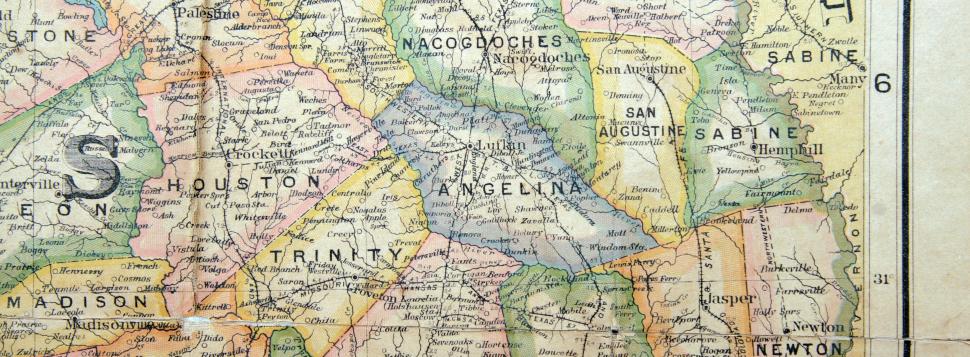 |
Nearby Counties: Cherokee, Nacogdoches, Houston, Trinity, Polk, Tyler, Jasper, San Augustine
To the north of the county is the Angelina River and the Neches River borders the south. The Sam Rayburn Reservoir, on the Angelina River, is the largest body of water in the county. It covers 114,500 acres and also covers parts of Jasper, Sabine, Nacogdoches and San Augustine Counties. It is a major recreational area for the county.
The land is densely forested with pine and hardwoods. The terrain is gently rolling hills. The Piney Woods area as longleaf, shortleaf, loblolly and slash pines which are very good for lumber production. Hardwoods generally available in the county are gum, magnolia, elm, hickory and oak. Farming is done on only about 20-30 percent of the land in the county. In the northern portion of the county, the soil is made up of clay/sand.
Size: 807 square miles
Elevation: 200-380 feet above sea level
Weather and Climate:
- Summer average high: 94 degrees F.
- Winter average low: 39 degrees F.
- Average Rainfall: 42.99
- Growing Season: 244 days
- The first freeze is generally around November 13th.
2019 Population: 86, 715
2018 – The median age was 37.2years old
In 2019, Angelina County, TX had a population of 86,715k people with a median age of 37.2 and a median household income of $50, 413.
HISTORY:
The original inhabitants of the area were the agricultural Indians of Caddoan and Atakapan stock. The name of the county came from a Hainai Indian girl who helped the Spanish missionaries in the late 1600’s. The tribe had plenty of food, a large population and an organized social organization.
The white man came here at the beginning of the 1800’s when Vincente Micheli exchanged a number of small items for a large portion of land. The Burris family came in 1820 to what is now Lufkin and to what was then known as Burris Prairie. The county was organized on 22 April 1846 when Nacogdoches County was divided. The area prospered due to good farming land and also because of the rivers which allowed water transportation.
By 1850 there were 1,165 residents in the county. There have been various county seats beginning with Marion. After Marion, there were Jonesville in 1854, Homer in 1858 and finally Lufkin in 1892. The Houston, East and West Texas Railway (Southern Pacific) was a major factor in the growth of Lufkin. Since mostly southerners settled in this area, there were many large plantations owned by a small group of families. In addition to the wealthy landowners, there was an equally large group of poorer farmers who lived in Angelina County.
Men from the county participated in the Civil War, but only 19 lost their lives in the fray. Once the Civil War was over, the major emphasis in the economy changed from livestock to the lumber industry. Other railroad lines came through the area, further bolstering the timber industry of the county. Lufkin quickly became the hub for these railroads. By 1900 there were over 17 sawmills operating in the county.
The World’s Fair of 1893 helped establish Southern Pine as a building material. Since Angelina County abounded in this commodity, it helped form a huge new economic base. Many towns in the county which flourished during the lumber boom or until their timber was gone, gradually shrunk until they no longer existed or were so small they barely were there. Some of these were: Homer, Baker, Clawson, Emporia, Hamlet, Lay, Popher, Yuno, Baber, Davisville, Renova, and Retrieve. Even though lumber remained a major part of the economy for many years, it finally peaked around 1913.
The great Depression of the 1930’s hit these lumber towns quite hard. Housing and building booms abruptly stopped and with that halt came a sharp decrease in demand for lumber and wood products. Many of the mills were forced to close with former owners and employees returning to their agricultural roots.
The Civilian Conservation Corps (CCC) for east Texas was headquartered in Lufkin during the 1930’s. By the mid-1940’s, the principal industries in the county were foundries, a creosoting plant, sawmills and a newsprint mill, Southland Paper Mills.
Angelina County, Texas was formed in 1846 from Nacogdoches County, Texas.
The county seat is Lufkin, TX.


 Angelina County
 Featured Community


 The Everything Store
  J.R.'s Collections
